Freetown is the capital of Sierra Leone and a major port city. During the country’s civil war between 1991 to 2002, about 500,000 farming families were displaced in the country, many of them moving to Freetown, and continued to remain there. The migration accelerated urbanisation compounding infrastructure issues, forcing people to build informal settlements and communities. Much of this urbanisation is unplanned. The road network in the city covers just 5% of the city’s land compared to the recommended 30%. This increases climate-risk vulnerability for an already vulnerable population, especially those living in informal settlements or working in the informal sector. In 2017, flooding and mudslides in Freetown killed more than 500 people.
The Urban SHADE project will be working in Susan’s Bay, CKG and Moyiba.
Susan’s Bay

Susan’s Bay is a coastal settlement in the center of Freetown, which reflects a long history of British colonial rule in Sierra Leone. The settlement is believed to have been named after the wife of one of the British colonial governors in the early twentieth century.
Susan’s Bay is a valuable harbour in the city that facilitates interior trade between Freetown residents and traders from coastal towns and villages in the north of Sierra Leone. The community continues to provide an important route for sea transportation of food items, including fruits and vegetables, fish, and firewood from across the Sierra Leone River into Freetown. Most residents, particularly women, are engaged in informal trade, which includes the sale of fish, charcoal, and other food items.
Susan’s Bay is a valuable harbour in the city that facilitates interior trade between Freetown residents and traders from coastal towns and villages in the north of Sierra Leone. The community continues to provide an important route for sea transportation of food items, including fruits and vegetables, fish, and firewood from across the Sierra Leone River into Freetown. Most residents, particularly women, are engaged in informal trade, which includes the sale of fish, charcoal, and other food items.
Susan’s Bay’s face changed after widespread internal migration during the war. There was rapid informal land reclamation, with houses built on ocean’s banks exposing residents to increased risks of flooding. The settlement is also at a risk of heatwaves and fire incidents.


Many houses are largely makeshift with corrugated iron sheet walls, lack good foundations, and are highly clustered, making them vulnerable to damage from yearly flooding and fire incidents. There are no access roads for vehicular entry, which impacts effective service delivery during emergencies, such as fire incidents. The lack of formal land deeds and building permits discourages housing improvement, with the fear of eviction.
There is one community health centre delivering primary healthcare services. The overwhelming population and bad experiences with formal health service provision, such as long wait times, high cost, trust issues, and perceived poor quality of care, often make many residents turn to traditional healers or pepe doctors (informal drug sellers) before seeking formal care.
Common health conditions include malaria, typhoid, and cold, resulting from poor water sanitation conditions and proximity to the coastline.

Photo credit: Dora Vangahun

CKG
CKG is in the west of Freetown. It is an abbreviation used to describe a network of small coastal settlements built on the banks of the Congo river known as Crab town, Kolle town and Gray Bush. They are considered one community because of their proximity and similar social and environmental characteristics. It lies close to Kingtom dumpsite, one of the two largest dumpsites in Freetown.

The settlement is believed to have started in the early 1970s when the National Stadium was constructed. The nearby vacant land became populated with people working on the construction of the stadium and those seeking livelihood opportunities. As migration to Gray Bush continued into the 1980s, people began to settle in the adjacent low-lying section of CKG called Crab Town, hunting crabs in the crocodile river. The coastal area near the Kingtom landfill was also reclaimed to form the other section of the community known as Kolleh Town.


After the civil war, an ensuing migration into Freetown increased overcrowding and congestion in the area. The presence of informal housing structures in waterlogged areas near the Kingtom landfill influences the recurrence of regular flooding and fire hazards, and increased air pollution.
The majority of the structures in Crab Town and Kolleh Town are made of corrugated iron sheets, while Gray Bush, sitting on top of Crab Town, largely comprises mud and cement brick structures. Livelihood activities of residents include fishing, small-scale businesses, and scavenging from the Kingtom dumpsite.
Like many informal settlements in Freetown, the residents of CKG have limited public provision of good drinking water. Most of the sources are dug wells used for domestic purposes, but are unfit for drinking due to contamination, especially in the rainy season when the community floods. The other risks are heatwaves, and falling rocks and boulders.
Limited pipe-borne water connected to the municipal grid is the main source of potable water, although it is also reported to be exposed to contamination in the event of flooding. The community also faces dire sanitation challenges. Residents at Crab town and Kolleh town, along the Congo River connect sewage pipes that empty sludge into the river. The lack of good drainage, poor waste management, and the existence of the Kingtom landfill at Kolleh town further exacerbate exposure of residents to health risks.
Moyiba

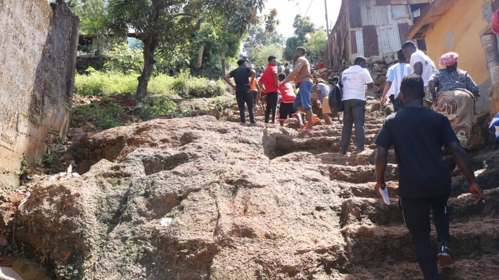
Moyiba is a hillside informal settlement in the east of Freetown, about 5 km from the Central Business District. Established as a farming community in 1929, it was transformed into a quarry in 1966 to support major city infrastructure projects in Freetown, including roads, bridges, the national port and stadium.
During the war, the settlement attracted many internally displaced persons and urban residents facing housing difficulties. The area is made of hills and has high levels of deforestation because of house construction and stone mining. (HISTORY)
Housing
The houses in Moyiba primarily are built with mud-brick walls and corrugated iron sheets, with a few makeshift structures, commonly called ‘pan-bodi’ (corrugated iron houses). As there are no formal land title deeds, most houses are informally owned by people or rented out. Since the settlement is located on a hill, it is prone to landslides, rockfalls, road accidents, and mudslides, especially during the rainy season.

The community is challenged with inadequate access to services, including healthcare, water, sanitation, and road network. Livelihood options are limited, and dominant ones like stone mining are precarious and often pose occupational and health risks.
Infrastructure
One unpaved road serves as a primary artery of the settlement. Public transport options are limited in this area as the road networks are precarious and rugged terrain. In the season, the roads are usually covered with mud and sometimes falling rocks block roads, inhibiting transportation and commuting. The excessive dust particles in the dry season further put residents at health risks. Most people walk on the roads and footpaths. The settlement is at risk of heatwaves, flooding, falling rocks and boulders, and mudslides.

Access to basic services in Moyiba is limited. Water is primarily obtained through community water points, piped water, and a dam. The community has poor access to drinking water.
Access to electricity is also limited. Sanitation facilities are inadequate in the settlements. Residents rely on pit latrines, flying toilets (defecation into polythene bags that are subsequently dumped along drainage channels) and open defecation. These poor sanitation practices contribute to water contamination and the prevalence of water-related diseases such as cholera, typhoid and malaria.

Access to healthcare has been a major challenge for residents in Moyiba community. Moyiba has one community health centre that provides mainly maternal health care, and a private health facility recently established in 2019. These centres are overstretched due to the overwhelming population and the limited service provision. Residents at the hilltop are more vulnerable to health care deprivation due to the long distance and the poor road to the health centre. The centres lack the capacity to treat major health conditions, hence limited to primary health service provision. Moreover, limited supply of drugs militates against quality service delivery. These conditions make most residents seek care from drug peddlers (itinerant drug sellers) who take the service to their door steps.